The coldest place + the coldest month in the Philippines -a perfect combination to hike. Weeks before our hike the Philippine Atmospheric Geophysical and Astronomical Services Administration (PAGASA) said Baguio City records lowest temperature in 2017 with 7.3 degrees Celsius. Me, Kris and our group PogiExplorers were very excited. However, along with the Baguio’s temperature news was the New People’s Army (NPA) rebels incident. Two trucks in Benguet were torched by the rebels. Baguio City was on red alert and Mt. Ulap was declared closed for safety reasons. Our excitement faded as we search for plan B mountain to hike. Luckily, it was announced to open again in the same day of our hike! 😀
Our simple Itinerary:
Day 0: Feb 17
8:00 AM: EDT Victory Liner Pasay
5:00 PM: EAT Baguio
Day 1: Feb 18
(Pinikpikan Adventours Itinerary)
Call Time/ Meet up Place
2am at 711 PNR road beside Caltex Gas Station near Victory Liner
Traverse Adventure via Sta Fe to Ampucao Entrance
– 2AM Call Time @ 711 at Victory Liner PNR Road Beside Caltex Gas Station
– 2:15 AM Departure TIme
– 3.00 AM Arrival at Ampucao Barangay
– 3:10 AM Registration at Ampucao
– 3:30 AM Start Trekking at Sta. Fe
– 4:00 AM Passing Pong-ol Burial Cave (No Pictorial)
– 5:30 AM Mt. Ulap Summit for Sunrise and Sea of Clouds
– 6:30 AM going down
– 8:00-9AM Gungal (Famous Rock Ridge)
– Passing at Paoay Hill
– 9:30-11:00 Am Going Down to Ampucao
– 11:00 Exit at Tomtombek
– 11:15 AM go back to Baguio
– 12:00-1:00 PM Lunch Time (Goodtaste Rice)
7:00 PM: Baguio nightlife/night market
Day: 2
04:00 AM: Assembly to Mt. Yangbew
05:00 AM: Stark hike
06:00 AM: Summit/Sunrise
08:00 AM: La Trinidad tour
10:00 AM: Back to Baguio.


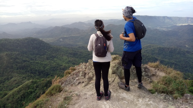
Mt. Ulap
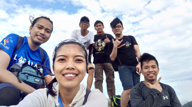
This is our 2nd time to climb Mt. Ulap for me and Kris. Our first climb there was last year 2016 when we celebrated our birthdays (yes birthdays, mine: March 9 hers: March 12). We normally travel by diy but when we planned to climb Mt. Ulap we decided to join Pinikpikan event to lessen the hassle of getting a transportation from Baguio to jumpoff vv and we made an excellent choice and we did it twice. Pinikpikan Adventours is a tour agency that offers events such as Mt. Ulap, Mt. Pulag, Sagada etc. Me and Kris were part of 1st and 38th Pinikpikan Mt. Ulap team and we had great experiences and adventures on both events. You will find some Mt. Ulap packages that includes van transportation from Manila but for us the pros of joining Pinikpikan are:
- Bus is more comfortable,
- You can manage your time before and after the hike,
- You can stay in Baguio (more rest and sidetrip),
- Itinerary is good,
- Reverse trail (less crowded),
- Lunch is ready (Goodtaste rice),
- Sir Paul is a great photographer,
- The drone.
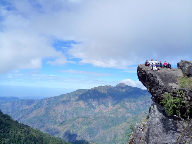
The official name of Mt. Ulap is Ampucao – Sta. Fe Ridge Eco-Trail. The ridge has 3 peaks: Ambanao Paoay Peak, Gungal Peak and Mt. Ulap. We completed the hike after roughly 8 hours which is the average time as per sir Paul. Ulap is truly amazing although this was our 2nd time.


Mt. Yangbew
A few hours of sleep after the Mt. Ulap and Baguio’s night market shopping, our next destination is Mt. Yangbew. I’ve never heard about this mountain before until the news of the holdup/stabbing incident. Mt. Yangbew is also known as Mt. Yangbo/Jambo/Jumbo. Based on the research and pictures on the web we expected this hike easy with a beautiful sunrise. So we planned to get there before sunrise. We followed instructions from other blogs on how to get there. Rode taxi from Baguio to Brgy Tawang of La Trinidad and we found the jumpoff near the Elementary school. Climbed for approximately 30 minutes and we reached the summit. It is very cloudy that time and unfortunately, we didn’t catch any sunrise. The wind is surprisingly strong and cold compared to Mt. Ulap. We ate our breakfast and took pictures and met some other people at the summit. The view is not as good as the peaks in Mt. Ulap, but still a great experience because of the weather and people that we met there.